Imperial Fringe, or, Map Time

Today’s gift for y’all is… a new map! A bigger map! A better map!

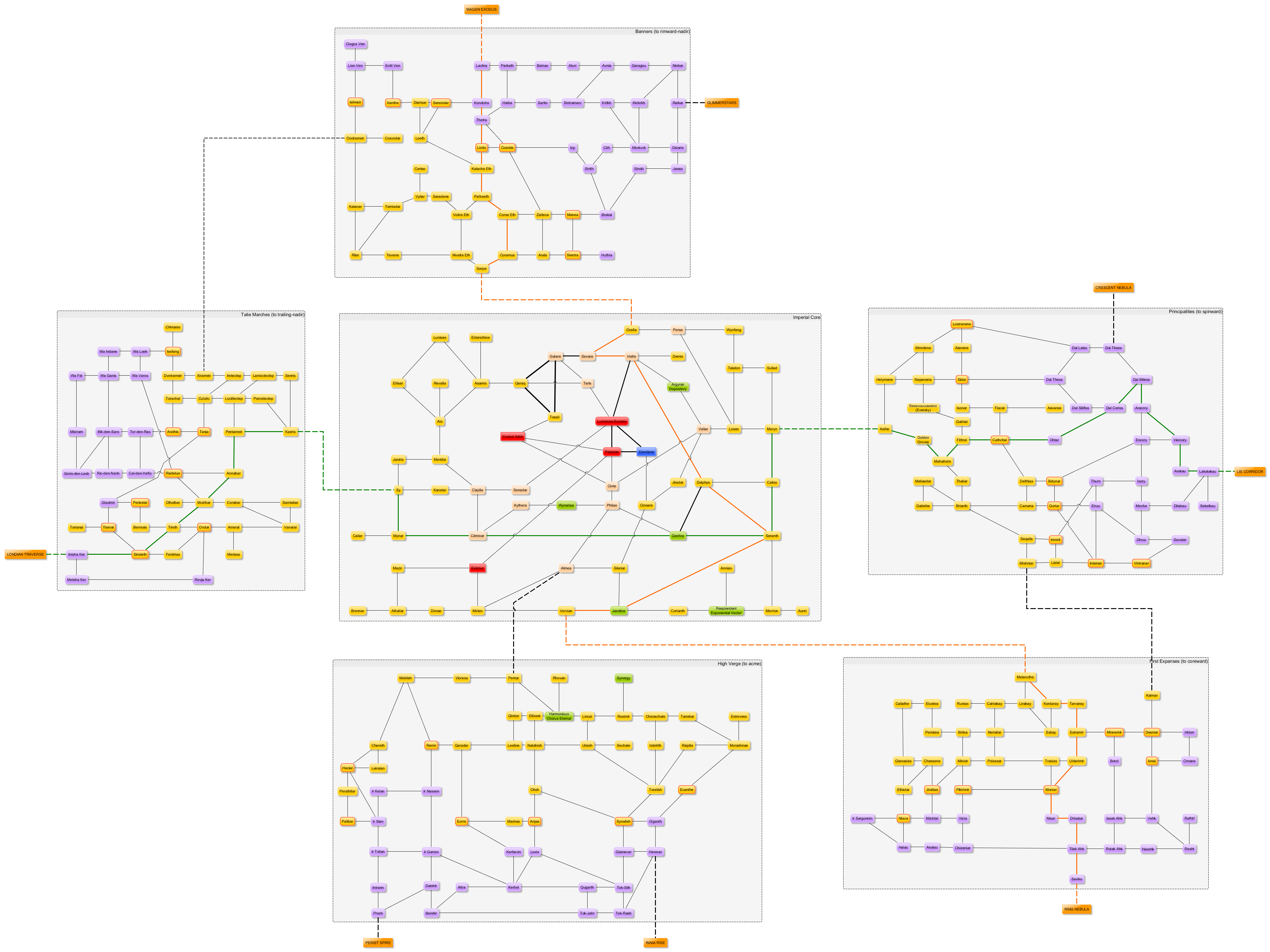
This map:

ImperialSpace

Which basically quintuples the amount of the Worlds that has been mapped on a system-by-system basis by extending that from the Imperial Core to the entire Imperial Fringe. Enjoy! (Although it’s big, so be aware when you click through.)

Key and notes:

  • As is usual, it’s a link-graph map, i.e., like a metro map, and a projection of 3D space onto 2D space besides. Neither stellar distances nor relative positions are in the least accurate except in the most general possible sense.
  • Each of the constellations (the Imperial Core plus the five constellations of the Imperial Fringe) represented is represented as a box containing the associated star systems. At the edges, the little orange boxes with CAPITAL LETTERS inside them represent links out to the other constellations of the Worlds.
  • The majority of Imperial star systems are represented as GOLD nodes. The exceptions to this are:
    • Certain important systems highlighted in RED (the throneworld, the IN Prime Base, the Cirys sphere and Cirys swarm); and
    • The system dedicated to the Conclave of Galactic Polities, indicated in BLUE; and
    • Imperial conlegial systems, indicated in GREEN; and
    • The original Thirteen Colonies (reached subluminally) represented in PALE GOLD.
  • Non-Imperial star systems are represented as PURPLE nodes.
  • Stargate pairs connecting systems are represented as SOLID lines. Stargate pairs connecting entire constellations are represented as DASHED lines. Crossing lines, as per the symbology, don’t actually intersect.
  • Arterial routes, i.e., extra-high-capacity stargate pairs, are represented as THICK lines.
  • The ORANGE line represents one major interstellar trade route passing through the Empire, the Mercantile Corridor. The GREEN line represents the other, the Lethiaza Trade Spine.
  • GOLD systems with a RED border are Imperial systems that connect directly to non-Imperial systems and as such form part of the Interface Defense Matrix. Also, when you get there, you have to clear immigration.

Enjoy!

Special extra challenges for the detail-oriented reader with some time to kill:

…how many different ante-Eldraeic roots for “world, place, land, planet, etc.” can you identify from the names of the various Imperial worlds seen on this map? And how many of those are actually exotic-species routes?

…how many and which extra-Imperial polities can you draw lines around based on commonalities of name scheme among the non-Imperial worlds?

Answers and questions in comments, please!

(P.S. Yes, that’s “Kerbol System” down there in the High Verge; having thrown that reference in as an homage, I’m hardly going to reverse myself now. Any assumptions one might make, however, about its planets, inhabitants, space program, or other details, however, are distinctly non-canonical.)

For Those Following Along At Home: Map!

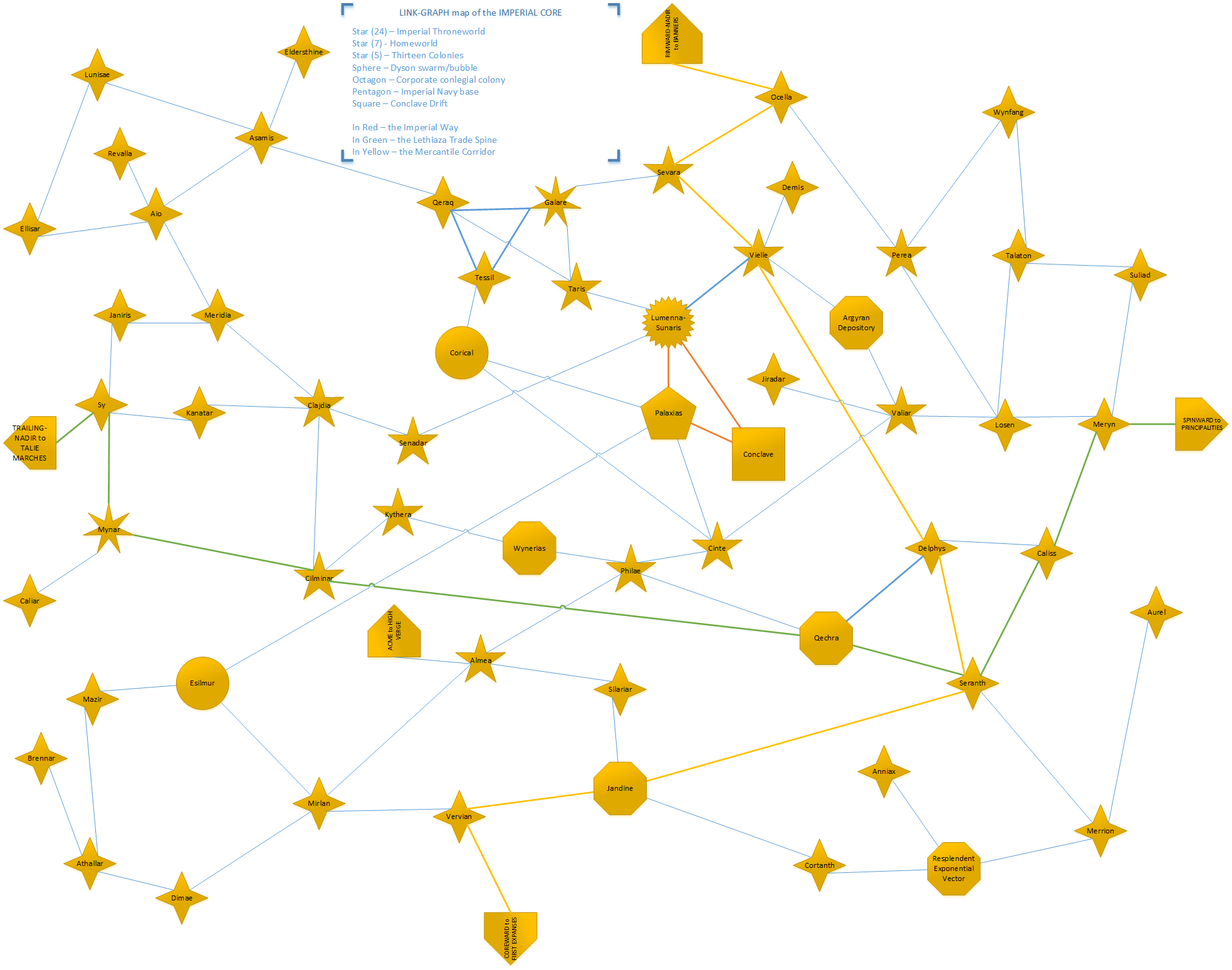
For those following along with these stories at home (or on holiday, or during your commute, or at work – why not?), I just found some time to clean up one of my rough sketch-maps of what the universe looks like, so thought I’d share it with you.  This is a relatively small part of the whole Associated Worlds (just one of the many linked constellations, which as you may recall in galactographic parlance means “cluster of stars linked with short-range wormholes, linked to other constellations by long-range wormholes), but it is one of the oldest and most important regions: namely, the Imperial Core itself, the 57 stars right at the heart of the web that includes the Empire’s throneworld, the Conclave Drift, and other such significant worlds, trade routes, etc., many of which have been mentioned in one context or another:

Imperial Core

(It’s quite a big image; click to enlarge.)  You’ll also notice that it’s what they call a “link-graph map”, meaning that it’s like a metro map – the links between stars are correct, but their actual relative physical positions are, ah, not necessarily so.  The more so because this is, of course, a 2D projection of 3D space.  This is exactly what you want for most interstellar travel, which is done purely by ‘gate – those who are flying around in relativistic clippers, on the other hand, will need to go buy a real-space starmap instead.  (Available from your local Grand Survey franchise!)

Enjoy!

Where’s Where in the Galaxy (1)

To begin at the beginning, the galaxy in which we dwell, the Starfall Arc, is a barred spiral galaxy, possessing four major spiral arms, and attended by a number of satellite galaxies, most prominent among which are the Greater and Lesser Ancíël Whirls.  These arms, from innermost to outermost, are Arilíäza, Vierníäza, Lethíäza (with its outer spur Sulíäza), and Dúraníäza.  The Associated Worlds are to be found near the outer edge of the Lethíäza arm.

The most important part of the Starfall Arc for us, as sophonts, is the middle third, encompassing Vierníäza, Lethíäza, and Sulíäza; those stars further from the galactic core than one-third of the galaxy’s radius, the Inner Third Ring, and so far enough away to avoid the high radiation, prevalence of supernovae, and other hazards of the core, and yet still close enough to for carbon and heavier elements to be prevalent in quantities sufficient to support the evolution of life.  The pulsar Tehelmír, the galactographic reference point closest to the center of the Associated Worlds, sits almost precisely in the center of this third, close to the galactic plane.

The Associated Worlds themselves make up a small fraction of one piece of this described life-friendly region. In theory, the Associated Worlds are composed of six nested spherical regions similar to a palel-fruit, from innermost to outermost:

The Imperial Core, the heartland of the Empire, containing the eldrae homeworld, the Thirteen Colonies, and other tightly-linked purely Imperial worlds;

The Imperial Fringe, a half-dozen highly Imperialized – but not exclusively Imperial – constellations close to the Imperial Core;

The Associated Worlds, the majority of the developed constellations of the Worlds, and what might be considered “civilized space”;

The Expansion Regions, the areas of the Periphery near the developed Worlds, currently targeted for colonization or other development by various polities of the Worlds, but not yet “fully civilized”.  The busy transitional zone between the worlds, and;

The Periphery, the furthest reaches of the stargate plexus, containing few if any colonies, and still being fully mapped and explored by the Grand Survey and other astrographic organizations.

The Outback, that area of space which, while unconnected to the stargate plexus, has still been reached by lighthuggers or starwisp probes, manned or unmanned, and so known to the Worlds in some terms not purely astronomical.  Everything beyond the Outback, space which has never been visited and is known only by astronomy, is simply the Beyond.

This simple theoretical picture, of course, is a nonsense.  The boundaries of the stargate plexus sprawl thousands of light years wide, and the galactic disk is not so thick; and colonization has not proceeded equally in all directions, but has proceeded more vigorously to coreward than to rimward.  Thus, the true shape of the Worlds resembles more a flattened egg, its point towards the galactic core; and to acme and nadir, the Expansion Regions are thin and the Periphery nonexistent, squeezed out by the edge of the useful galaxy.

Also, along its spinward edge, the stargate plexus of the Associated Worlds has intermingled, along a line three constellations in size, with that of the Voniensa Republic, another galactic civilization of nearly equal scope, again flattening the spinward side of the Worlds.  The area of the Expansion Regions closest to the Republic, the Crimson Expanse, Csell Buffer, and Vanguard Reaches, is informally known as the Seam.  The Expansion Regions and Periphery are thin here to spinward, as there has been little expansion of the plexus in areas which would be actively contested by the Republic.

And finally, as you might expect, these terms are themselves broadly disputed.  Few outside the Empire use the terms Imperial Core or Imperial Fringe, preferring not to escalate any polity of the Worlds above the others, galactographically speaking, or at least choosing their own to so escalate.  The term Associated Worlds, therefore, commonly refers to all of the developed systems within the Expansion Regions, including both the Core and the Fringe.  The use of the term Expansion Regions, too, is often controversial in its application to any given constellation both by Peripherals who dislike creeping colonization, and by those worlds which wish to consider themselves part of the metropolitan, and thus developed, Worlds.

Also unmentioned is the so-called Inner Periphery.  While the web of constellations incorporates many of the stars technically within the outer boundary of the stargate plexus, many remain unconnected, and accessible only by lighthugger.  While most of these have been visited, at least by unmanned probes, they are not considered part of their containing galactic region, due to their inaccessibility, forming a backwater region intermingled with the heart of civilized space.

Having defined these principal astrographic divisions of the space we inhabit, we can now discuss the economic, cultural, and less formal divisions of the Worlds.